Following on from our recent flag craft, I wanted to find a way to teach Harry a little bit more about geography and his place in the world. I remembered seeing a brilliant idea for a Me on the Map book at Counting Coconuts and so I thought that we could make one ourselves. It's a fun craft to do together with your child whether they are older or younger, and it helps them to understand a little bit about where they live and how that fits in with the rest of the world.
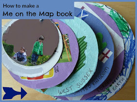
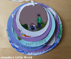
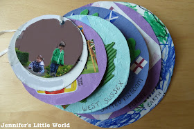
Here's the Me on the Map book that we made together:
To start with you need to make a plan for the pages that you want to include in your book.
My pages are:
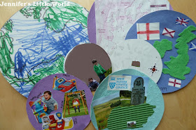
House - I took a photograph of our house and glued a photograph of Harry and Mia onto the front (I have blanked it out for privacy, we don't really live in a brown cloud!
Street - a map printed from Google maps of our street and surrounding streets with a tiny photo of the house (taken from the index sheet when I had the photographs printed) and a compass sticker.
Village - I cut some pictures from a magazine to represent the things that we do in our village - swings, baby group, the shops and the post office.
West Sussex - A cutout outline of West Sussex in coloured corrugated card with a couple of photos and logo taken from a free local magazine. The blue tissue paper in the background represents the sea!
United Kingdom - a cutout outline of the UK in felt with the individual flags from each country which make up the Union Flag and a larger England flag.
Europe - Very simple, just a printed outline map of Europe.
Earth - A simple cartoon style outline of Earth which Harry coloured in.
Each circle is cut from thin cardboard, I used the back of a cereal packet. Some of the circles were made using a template from a suitable object such as a bowl or cup, the rest were drawn freehand to fit in. There is about 1cm difference between each circle. Then I used a hole punch to make a hole in the top of each circle, before joining them together with some thin ribbon.
They can each be moved apart individually, or flipped over to form the book.
At the bottom of each circle I've written the description (I've blanked out our village and street name). I think that this is a really good way to help a child to understand the concept of geography. You might also like my post on teaching young children about geography.


What a great idea! I love that and you could get the kids involved making it too! Brilliant!
ReplyDeleteThank you! Yes there are lots of possibilities, you could also make it much larger (mine measures about 15cm across on the largest circle). You could also make it the other way round, with the earth in the smallest circle and the house in the largest.
DeleteThat is such a brilliant idea. I think I need to start collecting bits to make one like that with Laura.
ReplyDeleteIt is a great idea isn't it! (although not an original idea of mine unfortunately!) It did take a bit of planning, but really at a basic level all you need to do is print out some maps. I'd love to see it if you make one!
DeleteI have never seen anything like that before, what a clever idea.
ReplyDeleteIt is a great idea, it stuck out at me when I saw it ages ago and I was waiting for Harry to have the level of understanding for it
DeleteBrilliant idea. Will definitely be doing this with/for Kit.
ReplyDeleteOooh you must share a photo if you do, I'd love to see other versions!
DeleteLove this, def want to make one.
ReplyDelete